
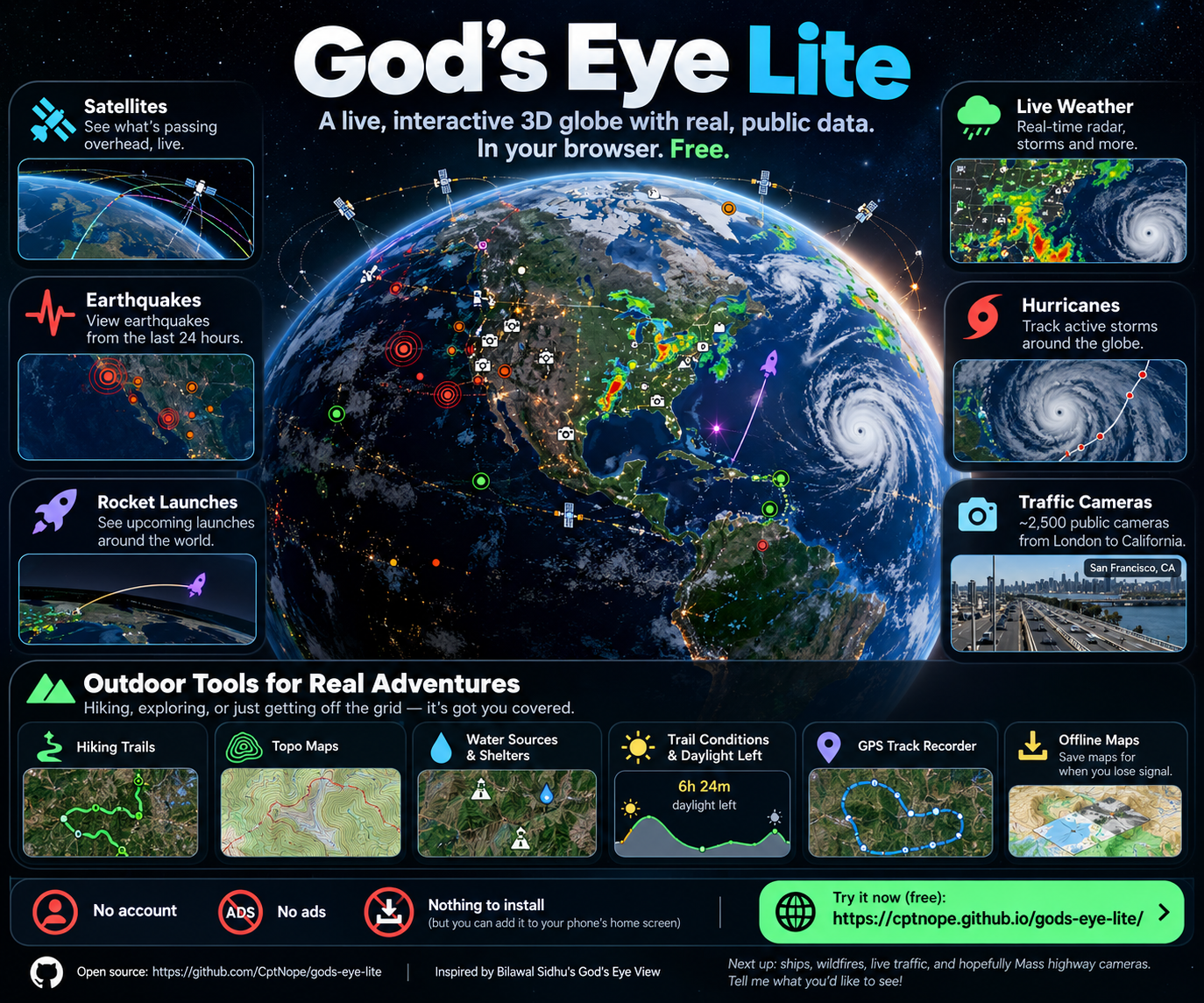
What if you could open a browser and see satellites passing overhead, earthquakes from the last 24 hours, upcoming rocket launches, live weather radar, tropical storms, public traffic cameras, hiking trails, and outdoor conditions — all on the same interactive 3D globe?
That question turned into God’s Eye Lite, an open-source Progressive Web App I built to bring public, real-world data together in one place.
There’s no account required, no subscription, no advertising, and nothing you have to install.
Just open the site.
You can also add it to your phone or desktop like a native application if you want.
View the source code on GitHub
A Different Way to Look at Public Data
There is an enormous amount of live and frequently updated information available publicly on the internet.
The problem is that it is scattered everywhere.
One site shows earthquakes.
Another shows weather radar.
Another tracks satellites.
Another provides rocket launch schedules.
State and municipal agencies publish traffic cameras.
OpenStreetMap contains hiking trails, peaks, shelters, springs, campsites, viewpoints, and countless other geographic features.
The information already exists.
God’s Eye Lite is my attempt to bring those pieces together into a single visual interface.
Instead of opening a dozen websites, you can move around the planet and turn different layers on and off as you need them.
Satellites Orbiting Above You
One of the first layers I wanted was satellite tracking.
God’s Eye Lite loads publicly available orbital information and calculates satellite positions directly in the browser.
You can explore satellites moving around the Earth, select one, inspect its information, and visualize its orbital path.
There is something very different about seeing orbital data represented spatially instead of looking at rows of numbers.
The scale becomes much easier to understand when you can actually rotate the planet underneath it.
Earthquakes From Around the World
The globe can also display earthquakes detected during the previous 24 hours using public earthquake data.
Instead of reading a conventional list of recent seismic events, you can immediately see where activity is concentrated geographically.
Zoom into a region, inspect individual events, or pull back and look at seismic activity from a global perspective.
It’s a simple example of why I enjoy geospatial visualization: location often tells part of the story that raw data alone doesn’t.
Upcoming Rocket Launches
God’s Eye Lite also includes an upcoming launch layer and countdown interface.
Rocket launches can be explored alongside the geography of the planet rather than existing as an isolated schedule.
For someone interested in spaceflight, it means satellite tracking, Earth observation, weather, and launch activity can all exist inside the same application.
Live Weather on a 3D Globe
Weather became one of the larger parts of the project.
Depending on the layer you enable, God’s Eye Lite can display things such as:
- Rain radar
- Satellite cloud imagery
- Lightning density
- Animated wind
- Tropical cyclone tracks
- Weather warnings and advisories
Radar can also be played back over time, which makes storm movement much easier to understand than a single static image.
What started as an interesting world-monitoring interface was gradually becoming useful for something else too.
The outdoors.
Turning It Into a Hiking and Outdoor Tool
Once I already had a globe, mapping system, device location, weather data, and public geographic information available, it seemed natural to see how useful the application could become while hiking.
That led to an entire outdoor toolset.
You can overlay hiking and mountain-bike trails and switch to topographic maps or terrain shading.
The app can also look around the visible area for useful OpenStreetMap data such as:
- Peaks
- Trailheads
- Water sources
- Springs
- Shelters
- Campsites
- Viewpoints
- Toilets
- Waterfalls
- Named hiking routes
Select an area and you can get current outdoor conditions including temperature, feels-like temperature, wind gusts, rain probability, UV conditions, elevation, and the amount of daylight remaining.
That last one is particularly useful.
Knowing that sunset is at 6:30 PM is one thing.
Seeing approximately how much daylight you have left while you’re actually on a trail is more immediately useful.
A GPS Track Recorder in the Browser
God’s Eye Lite can also use your phone’s location services as a basic GPS track recorder.
Start recording and it can track information such as:
- Distance traveled
- Time
- Elevation gain
- Your current coordinates
Tracks can be exported as GPX files for use elsewhere.
Location information and recorded tracks stay on the device rather than being uploaded to an account.
There isn’t an account to upload them to.
One limitation is inherent to browser-based PWAs: mobile operating systems can suspend web applications when they’re running in the background. For long, all-day GPS recording, a dedicated native hiking application is still the better tool.
But for something running entirely in a browser, I was surprised by how capable it could become.
Maps When You Lose Signal
Losing cellular coverage is normal when hiking, so I also wanted some level of offline functionality.
God’s Eye Lite can save map tiles from the current area so previously saved locations remain usable when connectivity disappears.
The Progressive Web App itself is also cached locally using a service worker.
That doesn’t magically make every live data source work without the internet — weather forecasts, live feeds, and online searches obviously still require connectivity — but the map itself can remain useful.
It’s another example of trying to make a web application behave more like something installed natively on the device.
Thousands of Public Traffic Cameras
One of the more interesting challenges was traffic cameras.
God’s Eye Lite currently brings together roughly 2,400 public traffic cameras from multiple regions, including cameras in California, London, British Columbia, Finland, Tallinn, Austin, Sydney, and Calgary.
The tricky part wasn’t necessarily displaying the images.
It was discovering the cameras.
Many transportation agencies allow camera images to be viewed publicly but block browsers from directly downloading the master list of camera locations.
The solution was to move that one step into GitHub Actions.
A scheduled workflow periodically builds the camera catalog, publishes it with the application, and lets the browser load the actual public images from their original operators.
It’s a good example of the kind of problem that appears when you’re deliberately trying to build something without maintaining a traditional application server.
Most of It Runs Directly in Your Browser
This became one of my favorite technical aspects of the project.
God’s Eye Lite isn’t backed by some large server continuously collecting all of this information.
The application is hosted primarily as static files through GitHub Pages.
Your browser does most of the work.
It talks directly to public data services for things like satellites, earthquakes, launches, weather, maps, trails, outdoor points, and search.
Where browser security restrictions make that impossible, I use other approaches such as GitHub Actions or a small Cloudflare Worker relay.
That keeps the infrastructure extremely lightweight.
The basic application can operate without requiring users to create accounts or supply API keys.
Optional services can be added by users who want extra capabilities.
Optional API Keys Stay Under the User’s Control
Some enhanced data sources require API keys.
Instead of storing those keys on my server, God’s Eye Lite includes an encrypted local vault.
Keys entered by a user are encrypted on their own device using a passphrase.
When the vault is unlocked, decrypted keys exist only in memory for that session.
Closing or locking the application clears them.
The goal is simple: I shouldn’t need possession of somebody else’s API credentials just because they want to use an optional feature in an open-source application.
Built as a Progressive Web App
God’s Eye Lite can be installed from your browser using Add to Home Screen or the browser’s install option.
Once installed, it behaves much more like a standalone application:
- Launch it from your home screen
- Run it full screen
- Cache the application locally
- Save areas for offline use
- Use device GPS
- Record tracks
- Share map views
But underneath all of that, it’s still a web application.
That was an important design goal.
I wanted someone to be able to click a link and immediately use it.
No installer.
No account creation.
No app store.
The Project That Inspired It
God’s Eye Lite was inspired by Bilawal Sidhu’s open-source God’s Eye View project:
https://github.com/bilawalsidhu/gods-eye-view
His project demonstrates just how much publicly available real-world information can be brought together into an interactive geospatial interface.
I loved the concept and wanted to experiment with a somewhat different constraint:
How much of this experience could I make available as a lightweight, static, installable web application?
That eventually became God’s Eye Lite.
The project isn’t intended to replace the original. It’s my own experiment with the idea, focused heavily on browser-native functionality, static hosting, outdoor use, and public/keyless data sources.
What’s Next?
There are plenty of directions I’d still like to take it.
Some of the layers I’m experimenting with or planning include:
- Live ship positions
- Active wildfires
- Live traffic conditions
- Additional public camera networks
- Better offline capabilities
- More environmental data
- Expanded outdoor tools
- Additional real-time public datasets
I’d particularly like to add Massachusetts highway cameras if I can find a reliable and appropriate public data source for them.
Live aircraft are another interesting challenge. Many free aircraft-tracking feeds deliberately block requests coming directly from browsers or common cloud networks, so supporting those reliably will likely require a different relay architecture.
Honestly, solving those kinds of problems is half the fun.
Why I Built It
Part of the reason I enjoy projects like this is that they sit at the intersection of several things I’m interested in:
web development, data visualization, mapping, public data, APIs, cybersecurity, PWAs, spaceflight, weather, and outdoor technology.
But there is also something fascinating about seeing how much information about our planet is already publicly accessible.
Satellites are broadcasting orbital data.
Seismometers are reporting earthquakes.
Weather satellites are imaging storms.
Transportation departments publish cameras.
Space agencies publish launch information.
Mapping communities document trails, springs, shelters, peaks, and roads.
Individual datasets may not seem remarkable on their own.
Put them together spatially, however, and you get a very different perspective.
That’s what God’s Eye Lite is really about.
Taking public information that already exists and making it easier — and more interesting — to explore.
Try God’s Eye Lite
God’s Eye Lite is free, open source, and runs directly in a modern browser.
No account is required.
No ads.
Nothing to install unless you want to add it to your device as a PWA.
Launch the app:
https://cptnope.github.io/gods-eye-lite/
View the source code:
https://github.com/CptNope/gods-eye-lite
Original God’s Eye View project by Bilawal Sidhu:
https://github.com/bilawalsidhu/gods-eye-view
If you try it, let me know what you’d like to see added next.