
Live Geospatial Data & Outdoor Intelligence PWA
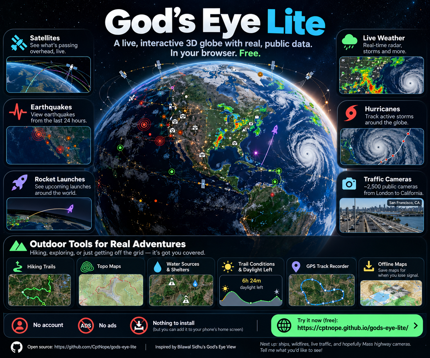
God’s Eye Lite is a browser-based geospatial visualization and outdoor mapping application built around an interactive 3D globe.
The project combines live and frequently updated public data from multiple sources into one interface, allowing users to explore what is happening around the world without jumping between separate websites and applications.
Users can track satellites, view recent earthquakes, explore upcoming rocket launches, monitor weather systems, follow tropical storms, browse thousands of public traffic cameras, and access a growing collection of outdoor navigation tools.
The application is free, open source, requires no account, and can be installed as a Progressive Web App on phones and desktop computers.
Bringing Public Data Together
A huge amount of useful real-world information is already available publicly online.
The challenge is that it is scattered across dozens of APIs, government websites, mapping platforms, and specialized services.
God’s Eye Lite brings many of those sources together into a unified geospatial interface.
Instead of looking at a list of earthquakes or satellite coordinates, the information can be explored spatially on a 3D model of the Earth.
Different data layers can be enabled and disabled depending on what the user wants to investigate.
Satellite Tracking
God’s Eye Lite displays satellites orbiting the Earth using public orbital data.
Satellite positions and orbital paths are calculated directly in the browser, allowing users to select individual objects and visualize how they move relative to the planet.
This turns raw orbital data into something much easier to understand visually.
Earthquakes and Global Events
Recent earthquakes can be displayed across the globe using public seismic data.
Users can immediately see where seismic activity is occurring, inspect individual events, and compare activity across different geographic regions.
The project also integrates upcoming rocket launch information, providing another real-time layer for users interested in spaceflight and orbital activity.
Live Weather Visualization
Weather became one of the largest parts of the project.
God’s Eye Lite supports layers for information such as:
- Weather radar
- Cloud imagery
- Animated wind
- Tropical cyclone tracks
- Lightning data
- Weather warnings and advisories
These datasets can be viewed directly on the globe, making it easier to understand how weather systems move across geographic regions.
Public Traffic Cameras
God’s Eye Lite aggregates thousands of publicly available traffic cameras from transportation agencies and municipalities.
The application currently includes cameras across multiple regions and countries.
This feature presented an interesting technical problem because many transportation systems make camera images public while preventing browsers from directly downloading their complete camera catalogs.
To solve this, GitHub Actions can periodically collect and process camera metadata before publishing it with the application.
The browser can then access the publicly available camera imagery without requiring a traditional application backend.
Hiking and Outdoor Tools
As the mapping capabilities grew, God’s Eye Lite also evolved into an outdoor navigation tool.
Users can explore:
- Hiking trails
- Mountain-bike trails
- Topographic maps
- Peaks
- Trailheads
- Water sources
- Springs
- Shelters
- Campsites
- Waterfalls
- Viewpoints
- Named hiking routes
Outdoor conditions can also include useful information such as temperature, wind, elevation, precipitation probability, UV conditions, and remaining daylight.
GPS Track Recording
God’s Eye Lite can use a device’s location services to record GPS tracks directly in the browser.
While recording, the application can track information such as:
- Distance traveled
- Recording time
- Current position
- Elevation
- Elevation gain
Recorded tracks can be exported as GPX files for use with other mapping and outdoor applications.
Location and track information remains on the user’s device rather than being uploaded to a centralized account.
Offline Maps
Cellular service can disappear quickly when hiking or traveling in remote areas.
God’s Eye Lite allows map areas to be cached locally for later use.
The application itself also uses Progressive Web App technology and service workers so much of the interface can continue functioning after it has been installed or previously loaded.
Live services still require an internet connection, but cached maps and application resources can remain available when connectivity is lost.
Lightweight Architecture
One of the most interesting technical aspects of God’s Eye Lite is how little traditional infrastructure it requires.
The application is primarily hosted as a static website.
Most data is retrieved directly from public services by the user’s browser.
Where browser security restrictions prevent this, the project uses lightweight infrastructure such as:
- GitHub Actions
- Static generated datasets
- Cloudflare Workers
- Service workers
- Browser-side processing
This allows the application to provide a surprisingly large amount of functionality without requiring a traditional server-backed platform.
Privacy and Optional API Keys
The core application does not require an account.
For optional services that require third-party API keys, God’s Eye Lite includes a local encrypted vault.
Keys can be encrypted on the user’s device and unlocked temporarily when needed.
The goal is to avoid unnecessarily collecting or storing another person’s API credentials on a centralized server.
Progressive Web App
God’s Eye Lite can be installed directly from a modern browser.
Once installed, it behaves similarly to a native application while still being built entirely with web technologies.
Users can:
- Launch it from their home screen
- Run it full screen
- Use device GPS
- Record tracks
- Cache application resources
- Save map areas
- Share map locations
There is no app store installation or account registration required.
Technical Stack
God’s Eye Lite uses technologies including:
- JavaScript
- CesiumJS
- Progressive Web App APIs
- Service Workers
- REST APIs
- OpenStreetMap data
- GitHub Actions
- GitHub Pages
- Cloudflare Workers
- Client-side geospatial processing
What’s Next
God’s Eye Lite is still evolving.
Future ideas include:
- Live ship tracking
- Wildfire data
- Live traffic conditions
- Additional traffic camera networks
- Expanded environmental datasets
- Improved offline capability
- More outdoor navigation features
- Additional real-time public data sources
The broader goal is to keep experimenting with how much useful real-world information can be combined into a lightweight application that runs primarily in the browser.
Live Application:
https://cptnope.github.io/gods-eye-lite/
Source Code:
https://github.com/CptNope/gods-eye-lite
Full Case Study:
https://jeremyanderson.tech/gods-eye-lite/